Wilmington's commercial corridors include the US-74 and US-17 commercial and industrial belts, the South Front Street and Cargo District redevelopment zones, the Wilmington International Airport area employment hub, and the Brunswick County suburban growth areas. Drone-based roof inspection in this market delivers thermal-imaging moisture mapping and GPS-tagged photographic documentation that supports insurance claims, capital planning, and pre-construction specification — eliminating the guesswork of manual walkovers on large commercial roofs and producing the documentation format that commercial property adjusters require.
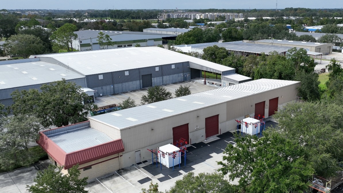
Drone Roof Inspection in Wilmington, NC delivers a comprehensive visual assessment of your entire commercial roof — every drain basin, seam, penetration flashing, and membrane surface condition — without putting a crew on the roof before the safety and structural conditions have been assessed. For large commercial roofs where a traditional walkover takes hours and misses low-visibility areas, aerial inspection with 4K camera and thermal imaging gives us a complete picture efficiently and without the foot traffic risk of deploying a crew on an unknown roof condition.
Thermal imaging during drone inspection identifies moisture trapped within the roof insulation assembly — which is one of the most important diagnostic findings a roof inspection can produce. Wet insulation retains heat differently than dry insulation, and a thermal pass during the right ambient conditions shows the exact location and extent of moisture infiltration within the assembly, even when the membrane surface shows no visible failure. That finding drives the critical specification decision: targeted repair and recovery versus full replacement. Thermal imaging eliminates the guesswork.
For insurance claims following hail events, wind damage, or other storm events in Wilmington, drone inspection provides GPS-tagged photographic documentation that adjusters can review remotely. Hail impact density maps, wind-related membrane displacement patterns, and equipment damage documentation produced from aerial footage meet the documentation standards used by commercial property insurers. We generate insurance reports in the standard format required by major commercial carriers and can turn a claim documentation package around within 24 hours of the inspection flight.
Before re-roofing proposals are developed, drone inspection confirms roof area measurements, identifies all penetrations and curb locations, and documents existing conditions for the specification. This reduces RFI and change order frequency during construction because the drawings are based on actual conditions, not assumptions from a visual walkover.
How we turn the services request into a usable scope
Drone Roof Inspection is documented around the roof evidence first: membrane condition, seams, flashing, drains, scuppers, penetrations, rooftop equipment, edge metal, and interior leak notes. That keeps the recommendation tied to what the building is showing instead of a broad square-foot assumption.
We also account for the Wilmington operating context near Cargo District, ILM Business Park, and Military Cutoff Road. Weather windows, tenant hours, loading docks, public access, and storm-season exposure all affect whether the next step should be temporary control, targeted repair, maintenance, coating, recover work, or replacement planning.
The result is a scope that can survive review. We identify the roof areas that need immediate attention, the items that should be watched through maintenance, the assumptions that affect pricing, and the details that should be photographed before any repair is hidden under new material.
Before work starts, we also make the practical constraints visible: roof access, material staging, forecast limits, daily close-in, interior protection, and the roof areas where wet insulation, deck damage, or edge-metal movement could change the budget after closer investigation.
We keep that decision record attached to the roof area instead of burying it in a generic estimate. If ownership chooses a repair path, the record shows what was intentionally left for later maintenance. If the building needs capital planning, the same notes become the starting point for alternates, phasing, exclusions, and the schedule constraints that affect final pricing.
That is also where communication gets practical: who can approve a change, when the roof can be opened, which entrances or loading areas have to stay clear, and what photos or notes need to be captured before the work is closed out.
When those details are settled early, pricing conversations are cleaner and the roof work is less likely to turn into an emergency change order.
That record also gives managers a clear baseline for the next inspection cycle.
- Document active leaks, prior patches, roof access, visible defects, and interior impact areas.
- Separate urgent work from capital work so the budget does not blur.
- Give ownership a clear record that can be used for approvals, procurement, or follow-up maintenance.
Drone Roof Inspection Questions
How does drone inspection compare to a traditional roof walkover?
Drone inspection covers the entire roof surface systematically at a consistent altitude, producing a full photographic record without the foot traffic that damages membranes and creates liability on unknown-condition roofs. It's particularly valuable on large commercial roofs where a walkover takes hours and misses low-slope areas where water pools aren't visible from standing height. Thermal imaging is not feasible during a manual walkover on a large roof — it requires the systematic coverage that only drone flight provides.
Can thermal imaging really show where moisture is trapped?
Yes — under the right conditions. Thermal imaging during the cool-down period after sunset is the standard protocol: the wet insulation retains heat longer than the dry insulation surrounding it, creating a visible thermal signature in the infrared image. The moisture map produced from a proper thermal pass is accurate enough to drive the specification for partial replacement versus full recovery — which can be the difference between a repair scope and a complete tearoff.
How do you use drone footage for an insurance claim?
We produce a GPS-tagged photographic report that documents hail impact locations and density, wind-related damage patterns, equipment and flashing damage, and overall membrane condition. The report is formatted to match the documentation requirements of major commercial property insurers and is suitable for submission directly to the adjuster. For contested claims, we can provide an expert statement based on the drone documentation.
What size and type of roofs are best suited to drone inspection?
Drone inspection is most valuable on large flat commercial roofs — logistics and industrial buildings, retail centers, office complexes, multi-building campuses. It's less critical on smaller or steeply sloped roofs where a manual inspection is fast and complete. For any commercial roof over 10,000 SF where a full condition assessment is needed, drone inspection is the more efficient and thorough approach.
How soon can you schedule a drone inspection in Wilmington?
Drone inspections in Wilmington are typically schedulable within 3-5 business days of contact. Emergency post-storm inspections for insurance claim documentation are prioritized and often schedulable within 24-48 hours following a significant weather event. We'll confirm the specific turnaround when you call.